On 26 May 2025, Kyiv was pummeled by a salvo of nine ballistic missiles and more than 900 drones and cruise missiles; none of the ballistic missiles was intercepted because too few Patriot batteries were available. At the same time, Russia is employing the new hypersonic Oreshnik vehicle, capable of flying at Mach 10, against industrial targets in Dnipro. In a scenario where a single warhead can cross the entire theater in minutes, every second shaved off the decision cycle saves lives.
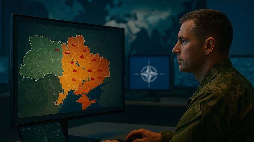
Ukrainian air defense relies on a mosaic of systems—Patriot, IRIS‑T, NASAMS, Sting FPV—that together achieve engagement probabilities close to 90–94 percent against drones and cruise missiles. Yet the speed with which threats change altitude, course, and radar signature makes it hard to know where to place the batteries, which sensors to assign to specific air corridors, and when to authorize fire without wasting precious munitions.
Digital Mission Engineering (DME) extends the digital twin from a single system to the mission level: a physics‑based twin that replicates, in real time, platforms, payloads, environment, and threats in 3 D. It integrates kinematic, RF, EO/IR, and radar modeling, automates coverage studies, and enables rapid trade‑offs throughout the life‑cycle, from concept to operation. The latest release has added optimal routing in satellite constellations and native visualization of radar returns.
In our case study on optimizing Ukrainian air defense, DME begins with the creation of a digital twin of the theater that fuses terrain models, near‑real‑time weather forecasts, friend/foe order of battle, and flight profiles of the hypersonic Oreshnik and Kinzhal vehicles.
On this basis, a dynamic coverage analysis is run that, in a matter of seconds—and in three dimensions—calculates the intercept volumes of the available Patriot batteries, overlaying them with NASAMS and IRIS‑T engagements to highlight corridors at risk.
Subsequent Monte Carlo simulations refine the shot doctrine: tens of thousands of trajectories are explored to identify the combination of fires that maximizes kill probability per missile and minimizes the wastage of critical munitions.
All of this feeds into an automatically generated “NATO‑style” report: coverage heat maps, time‑to‑impact graphs, and courses of action (COA) formatted to STANAG standards, ready for briefing in minutes rather than hours.
From the Baltic to the Pacific, DME extends its benefits far beyond the Ukrainian theater. In the Baltic and Arctic it allows simulation of A2/AD corridors dominated by S‑400 systems, testing safe resupply routes for naval convoys and evacuation flights in minutes. In the Eastern Mediterranean, integrating AIS tracks with EO/IR satellite sensors enables real‑time tracking of “kamikaze” naval drones and prevents the blockage of critical energy chokepoints. Finally, in the Indo‑Pacific, DME optimizes radar coverage and early warning against Chinese hypersonic glide vehicles, supporting integrated air‑space‑sea defense scenarios without exposing patrols to needless risk.
Adopting DME starts with a detailed inventory of sensors and effectors to build the digital‑twin database. Next comes a 72‑hour “quick‑look” scenario that rapidly highlights operational gaps and quantifies potential gains. With the first results in hand, the model is deployed to the cloud, leveraging parallel computing and cross‑force collaboration for large‑scale Monte Carlo simulations. The path closes with dedicated training and automation of STANAG reports via Python/REST scripts, keeping the model synchronized with the tactical picture without increasing the staff workload.
The war in Ukraine shows that the speed at which data are processed is now as much a survival factor as the speed of the weapon that threatens us. Digital Mission Engineering compresses the Sense‑Decide‑Act cycle from hours to minutes, transforming logistics chains, sensors, and weapons into a single cognitive network.